
5 top hikes in the Wicklow Mountains

See our pick of the five top hills to climb in the Wicklow mountains.
They are not the five highest, nor the hardest, but instead they offer a range of scenery, conditions and level of difficulty to have something for everyone.
Lugnaquilla
The highest mountain in the Wicklow and the highest point in Leinster, Lugnaquilla (925 metres) is an imposing giant of a mountain. Sitting like an upturned bowl in the landscape it dominates the southern end of the Wicklow mountains. Though not a technically difficult summit to reach, it does require stamina as the 800 metres of ascent required to reach the top is continuous and unrelenting.

The summit plateau is often enveloped in cloud and raked by a cold wind, so be sure to have adequate warm clothing and get your navigation up to speed before taking it on. As is befitting the highest point outside of county Kerry the views on a good day are far-reaching and magnificent, with the whole of the Wicklow mountains laid out before you to the north and the expanse of the Irish midlands to the south and west.
Often climbed from Fenton’s pub on it’s western side, the route from Baravore in Glenmalore on it’s eastern flank offers a more interesting ascent with some stunning mountain landscapes en route. There are a number of different routes up Lugnaquilla so careful navigation is required in descent to avoid ending up a long way from your start point.
Note that the green route (Zig-Zags) in the map below is now closed and there is no access into the valley from here.
To find out more about climbing Lugnaquilla with one of our guided groups check out the link .

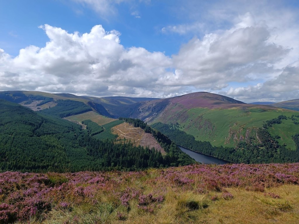
Tonelagee
At 817 metres, Tonelagee is the third highest in the Wicklow mountains. It’s name means literally ‘arse to the wind’ in gaeilge and the summit can indeed be exposed in windy weather. Sitting below the steep cliffs of it’s northeast face is Lough Ouler, which translates as ‘Eagle Lake’ but is more commonly known as the ‘heart-shaped lake’ due to it’s unusual and much photographed heart shape. The rounded summit is topped by a trig point and gives some superb all round views of the Wicklow mountains.

The summit is most easily reached from the Wicklow Gap (red route) but this misses out on the lovely eastern spur and the views over the lake. The route from Glenmacnass (blue) is very popular but be aware that it involves a river crossing on stepping stones at the start and this can become treacherous when the river floods. A route from the direction of Brockagh mountain (yellow route) is long and arduous.

Camaderry
Camaderry mountain (698 metres) and its slightly lower East Top sit across the Wicklow Gap from Tonelagee. The summit plateau is rocky and exposed and with the sparse vegetation give a ‘big mountain’ feel to the broad undulating ridge. To the north lies the industrial looking Turlough Hill with its huge reservoir perched on top which is used to power the turbines for the power station cut deep into the mountain below.

There are a number of ways to reach the summit, the easiest being from the Wicklow Gap (blue route) which uses the power station access road to reach the ridge. A longer but much nicer route (red) makes its way up grassy slopes from Glendalough, through ancient pine spinneys, to reach the East Top at the southern end of the ridge. This route can be combined with the old miners track (yellow) and St. Kevins Way to give a superb circular walk in varied and delightful landscapes.

Scarr
The name Scarr derives from Sgùrr, meaning a sharp pointed or conical hill and though Scarr could not be described as sharp pointed, from a northerly direction is does at least take on the appearance of a conical peak. The mountain reaches the relatively modest height of 640 metres but its greatest attributes are the wonderful views of Tonelagee and the Brockaghs from its summit and the nordic looking expanse of Lough Dan at the base of its northeastern slopes.

Lough Dan is a fine example of a ribbon lake, a long and narrow lake filling the valley left by a retreating glacier at the end of the last ice age.
Scarr is most easily accessed from the south, following the clear path that runs along the long easy angled ridge (yellow route). To get the best views of Lough Dan and the surrounding hills it is best to begin in Oldbridge and follow the path to Kanturk (red route). This can be combined with a descent on the blue route for a relatively easy circular walk.
Click the link for our itineraries and guided hiking trips of Scarr Mountain.

Derrybawn/Mullacor
Derrybawn is one of the best of the ‘small’ mountains in Wicklow though at 476 metres it is, strictly speaking, a hill. Often free from cloud when other tops are drapped in clag, from here you can get some of the best views in the area, with stunning views of Glendalough, Camaderry and Scarr.
This walk has a number of variations, both at the start and in the middle section, where forest road escape routes can quickly return you to the valley should legs get tired or the weather change. The high point of Mullacor is a bit of a lump, bleak and boggy on it’s large summit area, but from the north side it does give some amazing views of Lugnaquilla and Glenmalure.
It also takes in part of the Spinc, with vertiginous views of the zig-zags, Miners village and Glendalough.
If you would prefer to join a guided hike of Derrybawn and Mullacor please click the link to see our itineraries.
